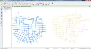
AfriGIS supports open-source initiatives and has recently released the Disconnected Islands QGIS Plugin. QGIS is a cross-platform free and open-source desktop geographic information system (GIS) application for data viewing, editing, and analysis. The QGIS plugin finds disconnected ‘islands’ in a road network layer, so that a routing tool will work between all nodes. A tolerance field allows for imperfect topology. This plugin runs on a polyline layer, building up a road (or rail, etc.) network graph of connected links. It then analyses connected subgraphs, ones that are connected to each other, but not connected to isolated or floating links. It creates an additional attribute containing the group ID of the subgraph. This can then be used to style the layer with Categorised styles, or Zoom to selection. The disconnected links can then be fixed.
The plugin has been downloaded more than 800 times. This plugin depends on the NetworkX module. Mac OS X users need to install it manually, simply by executing, in a Terminal: sudo easy_install networkx. Then restart QGIS. The plugin can be downloaded at http://hub.qgis.org/projects/disconnected-islands. There is also sample data available to test the plugin.
Plugin (Disconnected Islands QGIS):
https://plugins.qgis.org/plugins/disconnected-islands/
Source: http://www.ee.co.za/article/disconnected-islands-screenshots.html